GEO-Spatial / GIS,
GEO-Technical and other Technologies

TOYO provides all kinds of Geospatial / GIS-related services – a complete cycle of field data collection (underground and above-the-ground surveys), map making, and map-based reporting.

TOYO provides other Tech Services – Primarily, Multilingual DTP for the localization of documents and images.

info@toyogeotech.com

Don’t hesitate to write to us.

TOYO GeoTech Pvt. Ltd. (Formerly TOYO Computers Pvt. Ltd.)

GIS, CAD, Field Surveys, Other Tech Services
EL-125, Electronics Zone,
MIDC, Mahape,
Navi Mumbai - 400710, India

Highest quality professional services- To help our clients achieve their desired goals

GEOSPATIAL / GIS

All kinds of services covering the entire gamut – Digitization / Vectorization, Geo-referencing, Mapping and map data collection & updating using sources like Satellite Imagery, LiDAR, Drone, Aerial, Legacy Maps, etc. for Utilities (Telecom, Gas, Water, Electric), Cities / Towns / Villages, Environmental, Agriculture, Marketing, Logistics, Golf courses and many more.

field surveyS

Specialized in Surveys using Ground Penetrating Radar (GPR) and Pipe Locator (EPL) for Underground Utilities and other underground and above-the-ground features. Provide field surveys to collect data using Total Station (ETS), DGPS, GPS, LiDAR, Drones, etc.


multilingual dtp services

Experienced team to work on large or small projects that require DTP after translation. Almost all the languages of the world can be managed. Specialized in Adobe (InDesign, Framemaker, Photoshop, Illustrator) and Microsoft (Word, Excel, Powerpoint) software and other software, as required.


Providing services since 1997

TOYO has a practical approach toward the execution of all projects. Repeated orders from our clients are a testimonial to our high quality and delivery standards. 

Ground Penetrating Radar (GPR) services for Underground Utilities have been a speciality for us since 2011

Protect the utilities and other underground assets before you dig for any purpose.

Since 2011, we have helped several construction and infrastructure companies, saving them money in penalties.

By knowing the existing utilities and other assets, up to several meters below the ground, before digging or drilling, damages to these assets can be prevented as best possible.

0 +
Projects
0 +
Years of Experience
0 +
Happy Clients
0 +
Mapped Area (Sq Km)
map1
Land base and Assets Mapping for several "Compressed and Piped Natural Gas Distribution Utilities Companies" since 2014

Land base and Assets mapping is an essential item for all Pipe and Compressed Natural Gas Distribution companies.

Assets and Land base mapping are mandatory for all distribution companies as per the regulatory board. We have helped several companies in India with this activity, mapping several thousand sqm of land use, and several hundred kilometers of gas pipeline distribution assets using GIS, Satellite Imagery and Field Data collection. 

Precise Mapping

All kinds of GIS processes and quality tools are utilized to provide accurate and precise maps of Land base and assets.

Affordable and Accurate

Ensuring to get the desired accuracy at the desired price as per the requirement of the law is a challenge and we fulfill this requirement for all our piped gas distribution clients very well.

Mapping of Golf courses has been done by us for several clients since 2008

Digitized / Mapped Golf courses in GIS format are an essential item for every mobile or other application software used by a Golf player to record and improve the play

For a reputed GPS and Satellite Navigation systems company, all the Golf courses of the world were accurately mapped using satellite imagery. All features like Tee Boxes, Fairways, Greens, Roughs, Bunkers, Water bodies and other hazards along with the target lines were mapped to be directly used with a GPS or a mobile device.

Testimonials

TOYO Computers has provided The Nature Conservancy with very helpful GIS mapping support for over ten years. We have enjoyed working with their helpful staff over the years and each product they deliver has been accurate and on-time. Our work involves the time-critical collection of spatial data for conservation projects, mostly derived from satellite imagery. We have relied on their expertise, as they have the skills and talents to adapt to whatever mapping need we have.
Steve Schill
Lead Scientist

The Nature Conservancy
We have several years of experience with the TOYO team, on several projects of GIS data capture from satellite imagery and Sub-surface Utilities mapping for our infrastructure projects. For every task, they have always met our expectations of accurate quality and timely submission. We rely on the services provided by TOYO and would always recommend them as a reliable partner to work with.

Sabyasachi Nayak
Sr. Vice – President (Engineering)

JMC Projects (India) Ltd
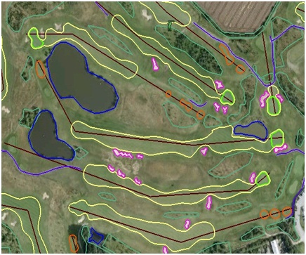
I would like to take this opportunity to thank Deven Lilani and his team at TOYO computers. Over the past 9 years, we have been more than pleased with their Geo-fencing services. You can always count on them for pure quality, and outstanding attention to detail, and no task is too big or too small for this team to handle. They will meet your expectations.
Francois Haughton
Business Development Professional

GAME GOLF
Toyo Computers has helped me over the years with many projects concerning change detection in orthophoto images. The quality of their work is very good and the service is always stable and reliable. I appreciate the efficient and friendly communication with project managers and the learning capacity of operators while working on the job. I would recommend Toyo Computers for your GIS and 2D and 3D mapping work.
GeoFocus, NL
CEO

Our Esteemed Clients

Home
Toyo GeoTech Pvt. Ltd.(Formerly Toyo Computers Pvt Ltd)
Close Search Window